 Time map (Simplified)
This algorithm provides a simpified access to the time-map endpoint.
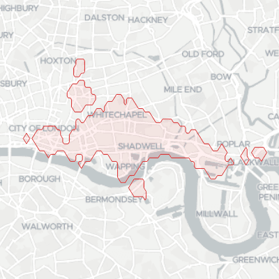
It can be used to get information such as a service area polygon based on travel time of different means of transport.
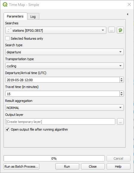
Searches: Choose a point layer from which represents input coordinates.
Search type: Whether the coordinates represent the departure or the arrival points.
Transportation type: Which transportation types to consider.
Departure/Arrival time: The departure or arrival time. Searches are time dependent, as depending on the date/time, public transport or traffic condition may be different.
Time zone: Define the time zone of the departure/arrival time.
Travel time (in minutes): The total duration from arrival to destination.
Result aggregation:
NORMALwill return a polygon for each departure/arrival searchUNIONwill return the union of all polygons for all departure/arrivals searches.INTERSECTIONwill return the intersection of all departure/arrival searches.
Output layer: Where to save the output layer. If you leave this empty, the result will be loaded as a temporary layer. It is still possible to save a temporary layer afterwards by right-clicking it in the legend and choosing “make permanent”.
 Time map (Advanced)
This algorithm provides advanced access to the time-map endpoint.
As it has a lot of options, it is recommended for beginners to rather use the simplified version of this algorithm.
It can be used to get information such as a service area polygon based on travel time of different means of transport.
The parameters match closely the API. They are best documented on the API documentation.
All parameters are expressions, which allow you to freely use the QGIS expression engine to define each of those parameters, which includes access to all features attributes.
The [fields to keep] parameter allows to specify fields from the inputs to keep in the output.
In the API, it is possible to specify which intersections or unions to compute. This doesn’t work well with typical GIS tabular inputs, so that this algorithm only allows to compute the INTERSECTION or UNION on all inputs.
Consider using this algorithm in conjunction with other QGIS algorithms if you need advanced INTERSECTION or UNION features.
Besides, while the API supports INTERSECTION and UNION of searches, the plugin performs these operations locally in order to work when batching queries. This means there may be minor differences in results geometries.